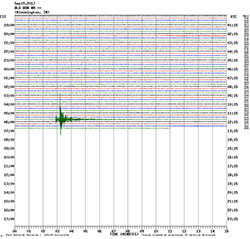
Preliminary earthquake report

Region: Illinois-Indiana border region
Geographic coordinates: 38.412N, 87.923W
Magnitude: 3.8
Depth: 15 km
Universal Time (UTC): 19 Sep 2017 11:47:29
Time near the Epicenter: 19 Sep 2017 06:47:29
Local standard time in your area: 19 Sep 2017 11:47:29


Location with respect to nearby cities:
3.1 km (1.9 mi) E of New Hope (historical), Illinois
45.3 km (28.1 mi) SW of Vincennes, Indiana
58.2 km (36.1 mi) NNW of Evansville, Indiana
70.2 km (43.5 mi) NNW of Henderson, Kentucky
214.4 km (132.9 mi) SE of Springfield, Illinois

Additional earthquake parameters

event ID: nm 60207021
version: 1
M-type: md
number of phases: 15
rms misfit: 0.09 seconds
horizontal location error: 0.3 km
vertical location error : 0.7 km
maximum azimuthal gap: 58 degrees
distance to nearest station: 31.3 km

This is a computer-generated message and has not yet been reviewed by a seismologist. For subsequent updates, maps, and technical information, see: http://earthquake.usgs.gov/earthquakes/eventpage/nm60207021 or https://earthquake.usgs.gov/

Center for Earthquake Research and Information U.S. Geological Survey University of Memphis http://www.memphis.edu/ceri/seismic